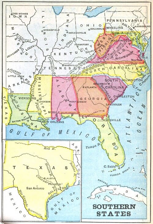
QUESTIONS - Examine the map and answer the questions. States in the Southeast
How many states are featured on the map?
Which is the largest featured state on the map?
Which state is farthest south?
What landform is Florida?
Which large island is south of Florida?
Which states are north of Florida?
Which river flows through the northern part of Alabama?
Into which river does the Tennessee River flow?
Which river flows between South Carolina and Georgia?
Into which ocean and gulf do the rivers of the featured states in the map flow?
Which three ranges of mountains are shown on the map?
Which are the most mountainous of the featured states?
Which of the featured states touch the Atlantic Ocean?
Which of the featured states touch the Gulf of Mexico?
Which of the featured states touch the Mississippi River?
What are the names of the ocean and gulf that surround Florida?
Where is Cape Sable?
Which strait separates Florida and Cuba?
ANSWERS
Eleven states are featured on the map.
Texas is the largest featured state on the map.
Florida is the state farthest south.
Florida is a Peninsula.
Cuba is south of Florida.
Georgia and Alabama are north of Florida.
The Tennessee River flows through the northern part of Alabama.
The Tennessee River flows into the Ohio River.
The Savannah River flows between South Carolina and Georgia.
The rivers of the featured states in the map flow into the Gulf of Mexico and Atlantic Ocean
The Cumberland, Allegheny, and Blue Ridge are the three ranges of mountains shown on the map.
West Virginia, Virginia, and North Carolina are the most mountainous of the featured states.
Maryland, Virginia, North Carolina, South Carolina, Georgia, and Florida touch the Atlantic Ocean.
Florida, Alabama, Mississippi, Louisiana, and Texas touch the Gulf of Mexico.
Louisiana and Mississippi touch the Mississippi River.
The Atlantic Ocean and Gulf of Mexico are the bodies of water surrounding Florida.
Cape Sable is in Florida.
The Florida Strait separates Florida and Cuba.
Notebook Work: Label the following on the map of the states in the southeast: Mexico, the Atlantic Ocean, the Gulf of Mexico, Florida, West Virginia, Texas, Maryland, Alabama, Virginia, Mississippi, North Carolina, South Carolina, Georgia, Louisiana.
 First Lessons in World Geography
World Geography
First Lessons in World Geography
World Geography


 About
About Curriculum
 Navigation